A Look at Earth's Geology and Geography With Kyle - Page 4
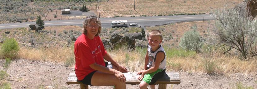
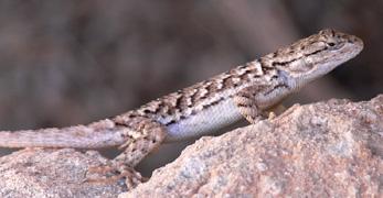
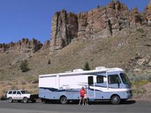
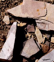
From the Richardson's Ranch, we then headed east to the Clarno Unit of the John Day Fossil Beds. Here, we parked the motorhome next to the highway and then climbed up a trail toward the Palisades cliffs. At the end of the trail, there was a bench to sit on to survey the great view, including our motorhome below. This is the same area where we took Kyle's cousin (Summer) last year, and now Kyle could see some of the geology of the past where fossil leaves can be seen in boulders beside the trail, and even fossilized limbs and logs in the nearby cliffs. All of these fossils were originally captured by volcanic lahars some 60 million years ago as they engulfed tropical forests. To get out of the hot sun, Kyle briefly found a shady niche in a very large boulder perched next to the trail. On the way back down the trail, he spotted a lizard that was staring at him intently. Could it be the same lizard that cousin Summer saw last year?
 |
 |
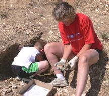 |
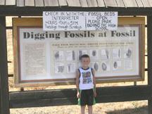
Next, we headed to the small town of Fossil where we set up camp in the same place as last year (at the local fairground). Here, it was Kyle's turn to try and find some leaf fossils on the hillside behind the high school. The same lady that helped us last year gave us some instruction on just how to go about digging and how to break apart the sedimentary rock to reveal fossil surprises. Kyle and Diana found a promising hole in the hillside and started digging away. Soon, they were trying the technique the lady taught them, by taking a rock slab in one hand, examining it to see the layering, and then striking it a sharp blow in a specific spot with a metal spatula to separate the layers. It was tedious and dirty work, and Kyle worked hard digging out hand sized chunks while Diana attempted to separate the rock layers. There was some success, and soon a box full of rocks was obtained (some to be dissected later).
Our next day involved some traveling, driving through rolling hills of wheat fields and observing the massive windmills producing electricity near Condon, Oregon, then going down one side and up the other side of the beautiful John Day River canyon, and then driving south along the Columbia River.
 |
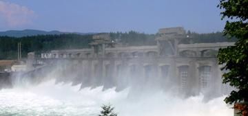 |
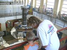
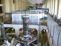
In the early afternoon, we came upon The Dalles Dam where we stopped at the visitor center. Here we looked at the exhibits they had and learned all about the Columbia River and the benefits which the dam provides. We were not able to take a tour of the dam here because their tour vehicle was out of commission so we continued to head south down the Columbia. Soon, we were at the Bonneville Dam. This is the very first dam that was established on the Columbia River and there is a lot of history here. When we went to the visitor center, there was a tour just leaving and we joined it. A tour director led us outside to where an old impeller was on display that used to be in one of the generator housings. It was a massive piece of machinery to be standing next to. We were then led to the powerhouse where we were able to view the inside of the building with its long row of generators. One of the generators just below our viewing area was being updated and we could watch the workers below working with the massive machinery. The tour director had much information on the dam and its workings and explained how the dam and its generators worked to produce electricity.
 |
 |
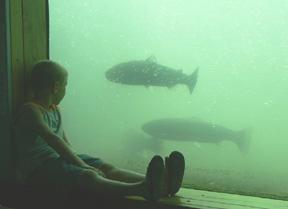
After spending time absorbing all we could see and learn, we left the powerhouse and then went to see the fish ladder where the fish are able to bypass the dam in heading up river. Not many fish were leaping out of the water at the ladder and we later found out that it was because they normally take an easier way by swimming through vertical slat openings in the ladder steps. A side door near the ladder allowed us to go inside and view the fish through large windows as they negotiated the ladder swimming upstream. Kyle found this a delight as he sat on the window ledge watching the fish swim past his nose.
 |
 |
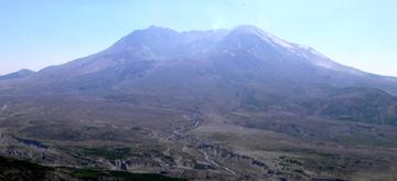 |
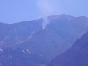
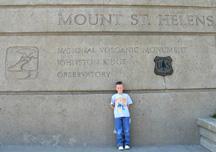
Our next stop was in the state of Washington where we found a campground at Seaquest State Park, which is close to Mount St. Helens. Here, across the highway from the park, is Mount St. Helens Visitor Center where we spent some time looking at exhibits, and Kyle learned all about Mount St. Helens and the large volcanic eruption that took place there on 18 May 1980. We then traveled up the road (on Spirit Lake highway) to the Johnson Ridge Observatory, which is situated at an elevation of 4,300 feet and has a sweeping view of Mount St. Helens and its crater. There is also a large exhibit hall here with many exhibits that provide instruction and explanation on what happened here in 1980. It also has a large 280 seat auditorium where a wonderful film of the mountain is shown, which incorporates a very dramatic effect at its ending. As the show ends, a small lighted sign asks the audience to remain seated, and then a large curtain is raised revealing a massive panoramic view of the actual mountain before them. With our binoculars, we could see many areas within the crater that were steaming all around and from atop the lava dome. Also, we could see that the wind was stirring up much ash and dust from around the mountain, which created much haze in the air.
After spending several hours in this place, we decided that Kyle had enough to absorb in this learning experience of geology and geography. He had been to the sea and sailed over huge sand dunes, been deep underground in dark tight places, examined rocks and fossils, seen the power of a great river producing electricity, and also the power of volcanic mountain building. And, it was now time to head for home.